|
|
 |
Sigiriya (The Lion Rock Citadel), Sri Lanka
The Royal Citadel of King Kasyapa (479-496 AD) (A world heritage Site)
Sigiriya Lion Rock citadel, also called Simha-giri (Sinhala: Lion Mountain) built by King Kasyapa (Kassapa) (479-497 A.D), grand nephew of Buddhist scholar monk illustrious Thera Mahanama, the first of the authors of Mahawamsa the great historical chronicle of Sri Lanka, is a fortified-walled and moated-royal city with living manifestations of glorious Sinhalese civilization: it's a unique combination of 5th century urban planning, architecture, engineering, hydraulic engineering, garden landscape designing, sculpture, art, painting and poetry. Sigiriya,a UNESCO World Heritage Site, is of immense archeological significance: it is one of the best preserved and most elaborate surviving urban sites in the South Asia from the first millennium A.D.
The grand monuments of Sri Lanka such as great Buddhist monasteries, temples, stupas and statues were intended to serve as religious edifices. During the annals of history of Sri Lanka, these great monuments helped survive and revive the Sinhalese Buddhist Civilization threatened by the marauding Dravidian invaders from Southern India since ancient to medieval era and then again by the maritime powers of Portuguese, Dutch and the British who bent on ripping the island nation of its treasures during the colonial era.
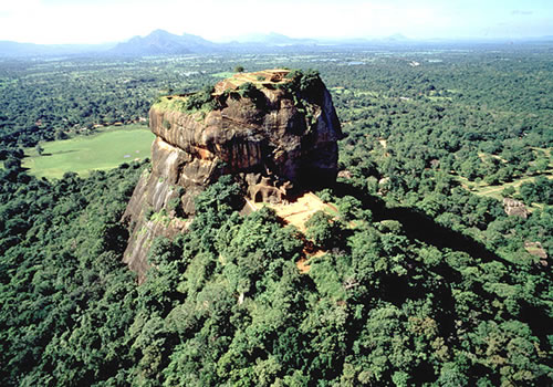
Sigiriya is of a sharply contrasting concept: it was a well planned royal city meant for a flamboyant king and his court with a palace complex centered around a solitary rock, an inselberg rising 200 m sheer out of the surrounding plains adorned with pleasant and vibrant green tropical vegetation. The great city of Sigiriya , though not of the glorious scale as the ancient capital of Anuardhapura or medieval capital of Polonnaruwa, still is a masterpiece of a citadel of a king with a heightened aesthetic disposition: it is treasure trove of art; a showcase of symbol of power; a shot at the symbolic reconstruction of Alakamanda, the mythical abode of God king Kuvera, the god of wealth.
The overall plan of Sigiriya reveals the master builder, King Kasyapa's love of nature. Such was his refined sensibilities, the king while designing the various components of the complex-parks, ponds, pavilions and pathways-let the natural profile of the land determine the positioning of the man-made structures. King Kassapa, in the fullest meanings of the words, was a nature lover-eco builder and art lover.
Today Sigiriya is recognized not only for the ruins of palace on the summit, a stepped plateau with a total extent of 1.5 hectares but also for the extensive assemblage of buildings, gardens, ponds, pathways, ramparts and moats set in a square module 2750 meters from east to west and 925 meters from north to south. Immediately to the east of the rock at Sigiriya is the Sigiriya man-made rainwater reservoir which not only irrigates the agricultural district but also feed the pools, ponds and fountains of Sigiriya by means of an underground network of conduits. King Kashyapa was the eldest son of righteous and heroic King Dathusena (461-479 A.D.) who reigned in Anuradhapura in great splendour and built Kalawewa, the 3rd largest man-made Rainwater reservoir of the island. The dam is 3 1/2 miles long, & 36 to 58 feet high with as spill of hammered granite, one of the canals, Jaya Ganga (also called Yoda Ela) feed out of the reservoir maintain a subtle gradient of 6 inches to the mile for first 17 miles of 90 miles.
Rock
The Lion Rock Citadel Sigiriya stands high above the surrounding
plain, visible for miles in all directions. The rock rests on as steep
mound that rises abruptly from the flat plain surrounding it. The rock
itself rises 200m & is sheer on all sides, in many places overhanging
the base. It is elliptical in horizontal plain with its flat summit
spreading an area of 1.5 hectares taking a gradual slop along the long
axis of the ellipse. The site is at once a palace & fortress. A vast
spectrum of intact monuments remains to provide the visitor with a
stunning insight into the ingenuity & creativity of its builders of
ancient Sri Lanka.
"The rock, then, was the sign of a sacred mountain: it was Meru
itself, the Cosmic Mountain at the center of the world, where the
symbolic planes of heaven & earth intersect, & Appearance for the single
endless moments disappears into Reality. Progress through the complex
constituted a true initiatory passage extending from western end of the
pleasure gardens up to the palace on the summit" John Lindsay Opie,
Island Ceylon (1970)
Asia's oldest surviving landscape garden
We park the vehicles half a kilometer away from the Asia's oldest
surviving landscape garden of a city fortress & walk in an arrow like
straight wide path towards a monolithic crag over the ramparts of the
lower citadel. The site compares with, albeit smaller in scale, no less
in grandeur, to other Asian wonders, Angkor Wat of 12th century AD (the
epitome of the high classical style of Khmer architecture) (1 million
visitors a year today) in Cambodia, ruins of the Gandharan city of
Takshila (also Takkasila or Taxila, Vedic/Hindu and Buddhist centre of
learning (6th century BC - 5th century AD) in Pakistan & the forbidden
city of Beijing (15th century AD). The Lion Rock Citadel Sigiriya is one
of the best-preserved sites where the layout of the building & gardens
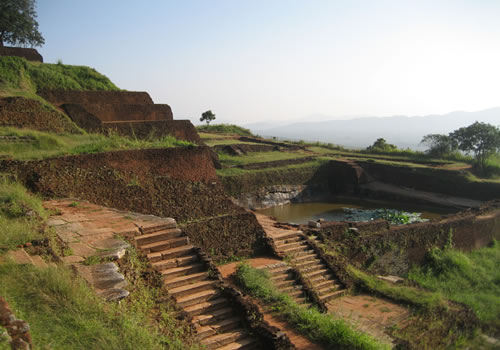
is still clearly evident. Outer moat, inner moat, water garden, fountain
garden, boulder gardens, terrace gardens & then to the foot of the
slope. Stone stairways climb the steep slope at the base of the rock,
winding through the remains of the lower parts of the palace, reaching a
terrace that traverses along the lower edge of the vertical face of the
rock.
Complex rampart system
Sigiriya has a very complex rampart system. The city was walled &
moated. Besides the inner & outer cities within the ramparts, there is
evidence of suburban dwellings immediately outside the walled area. The
complex is three kilometers from East to West & one kilometer from North
to South. The gardens of Sigiriya present a consummate combination of
natural flora & imaginative landscaping.
Grand urban planning
With brilliant combination of geometric square module & natural
topography, it speaks of grand urban planning. The architects &
engineers at the time took care to assimilate nature into the
constructions & never to deny it. Existing lakes, rocks & hills were
cleverly woven into the general plan: a combination of human mind &
natural world. The grand urban planning of the city, among other things,
is a wonderful manifestation of ancient Sinhalese concepts of Ecology &
United Biology as well.
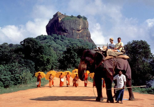
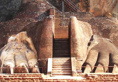
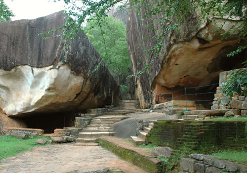
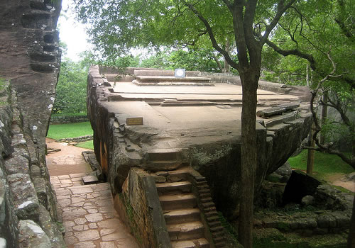
On the terrace
On the terrace are Audience hall, Cobra Hood cave, caves & hollows,
where early Buddhist monks lived, studied doctrine & meditated. Here we
are at the Lion gate. We stroll into the mouth & through the lion's
throat to the iron stairways, begin the main climb. Only the lion's
massive paws remain today, but they indicate how gigantic the rest of
the carving, the head with open mouth, which served as the one & only
entrance to the royal palace, must have been. The massive structure gave
the rock its name, Sigiriya , meaning Lion Rock. So we continue climbing
an iron staircase built by the British colonialists of Ceylon, a modern
replacement for the original brick stairway that had vanished along with
the head of the lion.
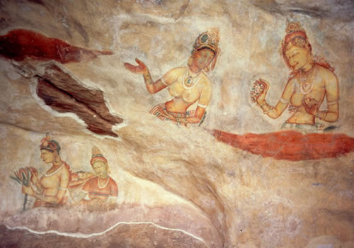
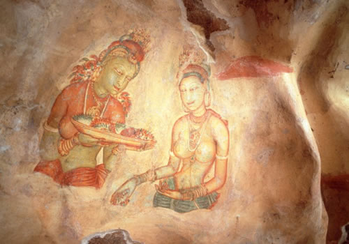
Lissome women of matchless grace: celestial nymphs
More than 100 meters above the ground level in a natural pocket of
the rock, which has been protected for 14 centuries from rain by an
overhang, we enjoy the sight of bare breasted apsaras (celestial
nymphs), or if you opt be rather irreverent, you may even call them
topless babes, that sexcite the mind but alas, only 22 exist today since
hundreds had been raped by ravages of time, weather & tragically by
vandalism too. The Lion Rock Citadel Sigiriya frescoes are the only
tapestry of secular art to have survived from the early Sinhalese
kingdoms. Nobody knows who painted these amazing frescoes. But the
artistic value & the beauty testify to a civilization of a nation of
great sophistication & refinement. The Sigiriya frescoes are said be of
same artistic tradition as of Ajanta frescoes at Ajanta caves in
Aurangabad district, state of Maharashtra in India.
Oldest known graffiti in the planet
A rock wall, once had such a sheen to have it named "Mirror Wall".
The Mirror Wall, close by on the opposite side of the frescoes,
preserves hundreds of oldest known graffiti in the planet inspired by
the great beauty of the celestial nymphs dating as early as 6th century
& till 14th century providing linguists with vital insight into the
evolution of the written & oral Sinhalese language. 700 poems therein
are deciphered by illustrious Dr. Senarath Paranavitarana. The
poems, which express the thoughts & emotions of ancient visitors to
Sigiriya , provide not only revealing comments on the paintings
themselves but also an insight into the in-born & cultivated
sensibilities of the time & its appreciation of art & beauty.
To the summit
We climb around, across & up the cliff face, along the narrow steel
staircase, which is simply bolted onto the sheer rock & supported by
railings to the open. Oh! yes, ascent of the rock is a stiff climb with
wind cutting in & making you bit vulnerable to a slip up of feet at the
climb. Hold the rail tight; foothold is fine, easy now. My pre-teen &
teenage nieces too climbed supported by us right behind them.
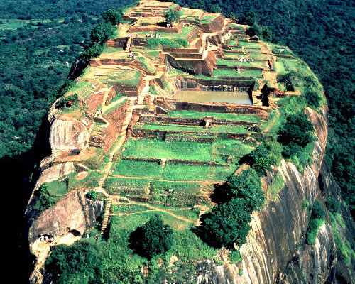
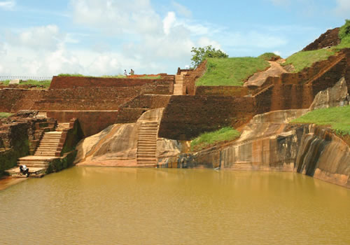
Summit
The summit of The Lion Rock Citadel Sigiriya , the stepped plateau
with a total extent of no less than 1.5 hectares cradled the palace of
King Kashyapa (479-496 AD). Today we have only the ruins of the summit
palace. A rock-cut throne & a couple of swimming pool-like large stone
tanks cut out of the rock, used for bathing still brim with clean water.
Since you are now sweating all over, would you dare a dive & swim? How
deep is water? Water had been pumped from the ground level to the top of
the rock. How did they pump water up to such height? At a sharp bend, a
stream of rushing water with its impact would find the way uphill around
the corner. But the technology used by the ancient engineers to pump
water to such a height is still unknown. Recent excavations found the
ruins of a steel plant (built circa 300 BC) in the east of Sigirya at
Aligala caves (evidence of one of the earliest days of iron production
in the world, carbon dating has determined it as 9th century) manned
solely by wind power. It is believed that water was channeled to the
summit of Sigiriya by means of an ingenious hydraulic system powered by
windmills. Oh! Wind, yes when I was six years old my father, who was
carrying me up in his alms, since I was running fever, had a tough climb
with the wind threatening to blow us off. That was during one of my
maternal grand father's yearly pilgrimages. My flamboyant maternal
grandfather, a philanthropist & an Ayurvedic physician Prangige Silmon
Peter Peiris Gunaratne of Lakshapatiya, Moratuwa seemed to have a soft
corner for the king who was flamboyant to the death. King Kashyapa
descended from his impregnable stronghold to the level field to face his
half brother in battle. When his army retreated in a bizarre confusion,
the king drew his dagger, (No, No, brother cried Prince Mugalan) slashed
his own throat, raised the blade high in the air & sheathed it again
before falling down dead off the elephant. Sigirya's halcyon days ended
with King Kasyapa's death. But the grandeur of the astonishing citadel
enlivens us with knowledge of ancient city development, technology, art,
irrigation & hydrology. Helicopters fly far away but the sound of rotor
blades & engines seems so close. The effects of the height sweep you off
the feet.
At this vantage point & height, you can see the beautiful milky white
huge rising dome of Mihintale Chaitya, the Buddhist shrine built by
King Devanam Piyatissa (contemporary of Emperor Asoka of India). That is at
the summit of rock mountain, Mihintale, the sanctuary.
Sigiriya wasn't a fortress of a fugitive, it was a palace of a god king
According to Senarat Paranavitana, King Kasyapa wasn't a fugitive. It was his rival, Prince Moggalana had fled to India for his own safety, having received no support from his countryman against King Kasyapa. King Kasyapa's reign lasted18 years, eleven of those years were at the sigiriya. This leads to the conclusion that it had taken seven years to build the Sigiriya Citadel. It wouldn't stand to logic that a fugitive would spent seven years building a fortress to defend himself from the enemies. In any event, when prince Moggalana returned, King Kasyapa descended from his fortress in the sky to the level ground to give and take battle.
Writes Senerat Paranavitana
Moreover: �The Lion Staircase-House, which is the key to the palace on the summit of Sigiriya, is accessible over the natural, though fairly steep, ground immediately below it, and the long, narrow and tortuous gallery which led to its was a wholly unnecessary means of approach unless it possessed some symbolic significance; as a means of defence it was quite useless.'
Sigiriya Hinterland
The archeology of Sigiriya in not confined to the ruins of the palace on the rock, gardens and the city. Recent archeological explorations have revealed that the extent of sites of great archeological value spread over the Sigiriya hinterland that was known in ancient times as the �Sihagiri Bim", the territory of Sigiriya. The archeological finds unearth a plethora of rural settlements, village agricultural and bathing reservoirs, protohistoric cemeteries, major iron-producing centers and an array of Buddhist monasteries.
The immediate greater Sigiriya area assimilates suburban settlements outside the city walls and along the Sigiriya Oya seasonal river. A major irrigation network to the south of the Sigiriya Rock is formed by the Sigiriya Mahawewa, a great man-made irrigation reservoir more than eight kilometers in length, and the twelve-kilometer long Vavala irrigation canal network.
Immediately to the north and south of the city is the ancient fortress of Mapalagama, with its �Cycopean' walls, dating from the first to the third centuries A.D., and Buddhist monasteries of Pidurangala and Ramkale.
As in almost all the ancient cities of Sri Lanka Holidays, Sigiriya too had Buddhist monasteries forming an integral part of the urban site: Pidurangala to the north and Ramakale to the south. Pidurangala Buddhist monastery has revealed evidence of prehistoric occupation. Returning to the recorded history of Sri Lanka, it must be outlined that Pidurangala, like Sigiriya, dates back to the earliest phase of the Early Historical period when it was a rock cave monastery. The rock carved inscriptions upon the drip-ledges of 4 of the cave entrances of 14 shelters reveal that Pidurangala was a Buddhist rock cave monastery since 3rd century BC.
Rediscovery of Sigiriya Lion Rock Citadel by Major Forbes in the year 1831
Following the discovery of Tika (Sinhala: commentary) at a potgula (Sinhala: library) at Mulgirigala (Mulkirigala) in 1826, the discoverer, George Turnour took upon the task of translating Mahawamsa (the Great Chronicle). However, the first printed edition of the English translation of Mahavamsa was published only in 1837. Meanwhile Major Forbes, 78th Highlanders in Ceylon, set about to rediscover King Kassapa's Sigiriya Citadel narrated in the 39th chapter of Mahavamsa. Major Forbes narrates the discovery in the year 1831:
"We returned from Polonnarrua by Minneria and Paecolom; and from thence struck off to the right to search for the ruins of Sigiri, an ancient capital of the island, hitherto unnoticed by Europeans. From paecolm, after riding four miles,-part of our way lying along the embankment, and part in the bed of a large tank,-the morning mists suddenly cleared away, and we found ourselves on the verge of a piece of water, reflecting from its unruffled surface the large forest-trees around, with the bare overhanging sides and brushwood-covered summit of the rock of Sigiri, which appeared to have started from the plain, and to frown defiance over the scanty fields and far-extending forests of the surrounding plain.
From the place where we halted I could distinguish massive stone walls appearing through the trees near the base of the rock, and now felt convinced that this was the very place I was anxious to discover."
Eleven years in Ceylon comprising sketches of the field sports and natural history of that colony and an account of its history and antiquities
written by Major Forbes. Published in London by Richard Bentley, New Burlington Street, Publisher in ordinary to Her Majesty, in the year 1840.
Polonnarrua is now spelled Polonnaruwa; Minneria is spelled Minneriya.
Extensive survey and research on Sigiriya by H.C. P. Bell
With the rediscovery of Sigiriya in 1831 and its reinscription in Mahawamsa, the glorious historical narrative, the Sigiriya Lion Rock Citadel became popular site of exploration and adventure- a challenge to the archeologists and the historians. In 1895 when Harry Charles Purvis Bell (1851 � 1937), the first commissioner of Archeology in Ceylon, was commissioned by Sir Arthur Gordon, the Governor of Ceylon, "to carry to completion the survey of either Sigiriya or Yapahuwa". Bell selected Sigiriya as it was of "higher antiquity and directly greater interest". He began by systemically clearing the jungle, surveying and mapping the rock and its environs and later moved on to excavate and restore the 'ruins'. During this time strong iron stays were bored into the rock and a sturdy wire ladder leading up to the fresco chamber was so that the paintings could be accessible to visitors. Almost a century later, Bell's biographers narrates his work at Sigiriya was "the most dramatic of the episode of his career, both in the actual danger and difficulty of the undertaking and in the peculiar interest of some of the discoveries made in the course of the excavations". H.C. P. Bell gained fame on his reporting of the work at Sigiriya to the Royal Asiatic Society (Ceylon Branch). In 1898 Bell was elected an Honorary Member of the Society. Bell's biographers narrate "In more ways than one Sigiriya was the peak of his carrer".
Archeological finds at Sigiriya: Sigiriya and International trade
Sigiriya excavations concluded in the year 1983 yielded more than 300 small copper coins similar to the most of the Roman and Indo-Roman copper coins found in ancient Sri Lanka. According to the archeologist Osmund Boprarachchi, the earliest coin found in the site are of Constantine 1, dated 317 AD and struck at the mint of Rome. The rest of the identified Roman coins belong to several other Roman Emperors: Palestinian 1 and 11, Valens, Gratian, Theodosius 1 and 11, Arcadious and Honorius. The most recent Roman coin belongs to Marcian (450-457 AD). According to Bopearachchi, the large majority of those Roman coins was found in the Kassapan layers, i.e. the archeological excavation layers that unearthed the finds that belonged to the reign of Sigiri Kassapa. According to Osmund Bopearachchi (C. N. R. S. Paris), the total number of Roman coins found at Sigiriya was nearly 3000. Since it is quite evident that the coins found at the site are the ones which were in circulation mainly during the Kassapan period, the archeologist Boperarchchi concludes King Kassapa tolerated or perhaps even promoted free circulation of foreign coins in his kingdom. Pushing the argument a notch higher, he says it could have been possible that new ideas and concepts from the foreign lands had enjoyed king's blessings. The argument is strong indeed. After all, a king who set his sight upon to reign as if a god king wouldn't have liked to live in seclusion, but open up the interaction and commerce with foreign nations so that his glory would be extolled overseas.
 |
Map of Sigiriya
1. Main Car Park 2. Herbal Garden 3. Outer Rampart 4. Outer Moat 5. Western Entrance 6. Middle Rampart 7. Inner Moat 8. Inner Rampart 9. Water Garden 10. Summer Palace 11. Southern Gateway 12. Boulder Garden 13. Lion’s Paw Terrace 14. Palace Complex
Above map is reproduced herein by the kind courtesy of Central Cultral Fund, Colombo, Sri Lanka
Cultural triangle; Sigiriya Lion Rock Citadel |
|
|
 |
|
 |
|
| |
 |
 |
|
click
on photo to enlarge |
|